Bitacora de un VIAJE A KARUKINKA Febrero 2011
Camila Marambio me invitó a participar en una curatoría de su dirección, a un encuentro- expedición al territorio de KARUKINKA, ubicado al sur de la Isla Grande de Tierra Del Fuego, en la región de Magallanes. Iniciamos el viaje desde Punta Arenas, un grupo de 15 invitados, en una caravana de 4 camionetas con todo el equipaje y víveres para una jornada de una semana. El territorio de Karukinka se extiende por el sur a lo largo de la ribera norte del seno de Almirantazgo, hasta el estrecho de Magallanes por el Poniente, por el Este llega hasta el límite con Argentina y, por el Norte se adentra en Pampa Guanaco. Atravesamos el Estrecho de Magallanes por el extremo noreste, en Punta Delgada, para evitar el fuerte viento que suele dificultar la travesía del estrecho y que ha abundado de naufragios la historia de su navegación.
Lunes 14, febrero, 2011 Territorio de KARUKINKA
Posta de Vicuña Despues de un viaje en caravana, de 6 horas, llegamos al atardecer a la posta de Vicuña, que fue nuestra base de operaciones por tres noches y lugar de varias charlas y presentaciones de los participantes del grupo.
LISTA DE PARTICIPANTES .- Camila Marambio (ch.) curadora y organizadora de la expedición. Bárbara Saavedra (ch.) bióloga y directora de Wild Life Conservation Society Chile .- Daniela Droguett (ch.) bióloga marina, investigadora de la vida de las ballenas (staff W.C.S ) .- Geir Tore Holm (nor.) artista visual .- Sossa Sorgensen (nor.) artista Visual .- Karoline Tampere (estonia. ) curadora .- Steffan Mitterer (austria) músico y artista visual .- Pierre Lasserre (canada ) economista Univ. Montreal .- Fabienne Lasserre (canada) artista visual (New York) .- Melissa Memory (USA) arqueóloga .-Christy Cast (USA) artista visual .- Paola Bezani (ch. ) artista visual (Consejo Regional de la Cultura de Punta Arenas) .- Julio Contreras (ch.) médico y budista (Punta Arenas). .- Ivette Martínez (ch.) pedagoga (Caleta María) .- Kiko ………. ( USA) activista político ecológico .- J. Pablo Langlois (ch.) arquitecto y artista visual .- Mauricio Chacón (ch.) guardaparque ( W.C.S.) .- María Luisa Murillo (ch.) fotógrafa y directora del Museo Alberto Beareswyl Pittet, Puerto Yartou
Las presentaciones se hacían normalmente por la mañana después de desayunar y por las tardes antes o después de comida según como se había desarrollado el día y el tiempo de comentarios que se suscitaban.
Todos los participantes hicimos presentaciones sobre la actividad que desarrollamos en nuestra cotidianeidad de vida.
La luz eléctrica era provista por un motor generador a parafina JP4 (combustible de aviación) entre las 6.30 am. y las 11.00 pm. Para el resto de las horas había que recurrir a las linternas personales.
LAS CAMINATAS Todos los días había un programa de caminatas y constituían la base más importante del programa, por lo variado de los recorridos, lo sorprendente del paisaje , las dificultades que surgían al paso y la información y conocimiento que adquiríamos de la naturaleza del lugar que atravesamos. Las camionetas de apoyo nos trasladaban en las grandes distancias donde había caminos.
(Martes 15 de febrero) Caminata de subida al cerro Pietro. Tomamos tres horas hasta la cumbre de 200 m. de altura desde la base.
Desde la cumbre de rocas se domina parte importante del valle del río Grande y de los bosques de lenga, que abarcan enormes extensiones de lomajes, como nubes de follaje verde, enmarcando el valle.
La subida por tramos en medio del bosque en pendiente presenta dificultades de recorrido a pesar de las marcas (flechas pintadas) cada cierto trecho. Estas guías son indispensables para el ascenso porque la densidad de bosque hace perder el sentido de ubicación. Yo llegué extenuado y pensé mas de una vez abandonar la caravana (era el último de la cola) pero Daniela se sacrificó y me acompañó dándome aliento y descansando a trechos mas seguidos, pero finalmente llegué y valió la pena la observación desde la cima. El descenso fue por una ruta más directa pero más peligrosa por lo resbaladiza y empinada, como huella de paso de cabras, además, me tocó una granizada muy fuerte y ventosa que dificultaba el caminar y el riesgo de desbarrancarse.
(Miércoles 15 de febrero) Emprendimos al día siguiente, temprano, una segunda caminata a Caleta María, a las orillas del Seno Almirantazgo, atravesando el bosque de lenga, con un tiempo de caminata de 4 horas para los más rapidos y hasta 6 horas para los mas lentos como yo, con descansos de 10 minutos cada hora .
Se inició el trayecto en caravana de 5 camionetas hasta orillas del lago Fagnano, donde hicimos pic-nic junto al embarcadero del Cuerpo Militar del Trabajo, que construía el camino que llevaría hasta Caleta María (hoy ya terminado). Ahí nos dejaron las camionetas, atravesamos en barcaza el lago e iniciamos nuestra caminata por el tupido bosque de lengas, canelos y otros árboles. Me llamó la atención encontrar tanto renuevo de canelos, pues pensaba que eran más propios de la zona de la Araucanía (árbol sagrado de los mapuches).
Entre el bosque crece una variedad de plantas silvestres: arándanos, frutillas cuyo fruto crece pegado al suelo como protección natural contra los fuertes vientos, la nieve y los guanacos, aunque vimos solo huellas de éstos en esta caminata.
Hay variedad de hongos que requerirían de la información de un experto para distinguir los comestibles de otros; alucinógenos, venenosos, etc.
Otra curiosidad para mí, fueron los pozos de “turba”, un material orgánico de color naranjo y aspecto de tallarines gruesos y porosos que absorben agua como una esponja gigante (puede alcanzar 1.00m a 1.50 m de profundidad). Cuando se pisa una turba, el pié se hunde fácilmente unos 50 cm. Lo que hace perder estabilidad y caer (ojalá no dentro del pozo de turba).
En realidad esta travesía requiere de equipaje adecuado para la eventualidad de sorpresivas lluvias, el saco de dormir a cuestas, las provisiones de alimentación fáciles y energéticas como galletas, chocolates, y botellas de agua, que pudimos rellenar en los esteros de agua cristalina que atravesamos para refrescarnos.
Recuerdo esto porque en las jornada de caminata de 6 horas diarias de ida y retorno al día siguiente, tuvimos dos días de bastante calor (solo llovió en la noche que estuvimos bajo techo en caleta María). Aquí aprovechamos en hacer una gran fogata para secar la ropa y los zapatos mojados en los cruces de esteros y la lluvia de la noche, además de la parrillada con salchichas y chorizos.
A la mañana siguiente, a las 9.00 am. iniciamos el retorno repartidos en tres grupos: primero los mas lentos (donde iba yo) y luego con intervalos de una hora, los otros dos grupos, lo que permitió que todos llegáramos al mismo tiempo al embarcadero.
Me tocó ver también una diminuta planta carnívora, (de un cm. de diámetro) de color rosado y carnoso como el interior de nuestra boca, que crece pegada al suelo y que se alimenta de insectos de tierra.
Volví a ver los canelos que crecen entre las lengas y pensé que serían en gran parte arrancados con el paso de la maquinaria pesada que usaban para construir el camino que alcanzaría hasta la orilla del Seno de Almirantazgo.
Pensé si ¿realmente será necesario construir un camino de 12 m. de ancho y estabilizado, a un costo altísimo de construcción y mantención, para llevar un utópico turismo al borde del Seno, atravesando un lugar donde irán no mas de 5 personas promedio diario en temporada de verano, cuándo el verdadero valor de este recorrido está en la caminata y la aventura? ¿No bastaría una huella que facilite las caminatas y el eventual paso de un vehículo de apoyo, y mantener la proximidad de la selva al paso de caminante?
Reflexión que a mi juicio vale la pena para repensar y revisar el daño ambiental que se va a producir con la dudosa ventaja de la civilización.
(Viernes 18 de febrero) Traslado a residencia en lago Escondido. A las 10 am. la caravana de camionetas retomó rumbo a Lago Escondido, otra residencia de Karukinka, donde llegamos a las 3.00 pm. Hermosísimo lugar en el borde de un bosque de lenga y con una vista sobre el valle del rio Grande que se pierde serpenteando en la distancia.
Cada quién uno tuvo una tarde contemplativa…..
Sentarse en el borde del corte en el cerro para mirar el valle del río serpenteante hasta perderse en la bruma luminosa del horizonte, como en una perspectiva renacentista, y contemplar sin pretender agregar nada al momento y solo mirar lo que ese valle y ese río entregaban es terapia para el espíritu.
(Sabado 19 de febrero) Para el día 19 se había programado otro recorrido, a Lago Escondido, pero yo preferí quedarme en la posada, para repetirme en otro horario (y con otra luz) el paisaje de la tarde anterior. Aproveché de visitar un antiguo galpón de esquila hoy abandonado pero bien conservado, ver los canales y desvíos del agua que producen los castores (nefastos ingenieros como los llaman por allí) y aprender a pescar en un remanso del río, con mosca.
Despues de las 4.00 pm., acompañé a los guardabosques a preparar el fuego para el asado de despedida de la excursión.
Se mató una oveja entera partida en dos mitades; dos largas tiras de costillar colocadas verticalmente ensartadas en fierros, por ambos costados de la fogata.
A las 5.00 pm, hora en que llegaron los caminantes, todos fuimos a disfrutar del asado en el comedor, donde se hicieron las últimas presentaciones y todos tuvimos que proponer ideas para cómo seguir trabajando juntos en torno a los asutnos de conservación del Parque. El domingo se inició el retorno a Punta Arenas y el grupo se redistribuyó en las camionetas ya que algunos se deviaron para conocer Puerto Yartou ( en frente de Isla Dawson) y otros retornamos a la ciudad.
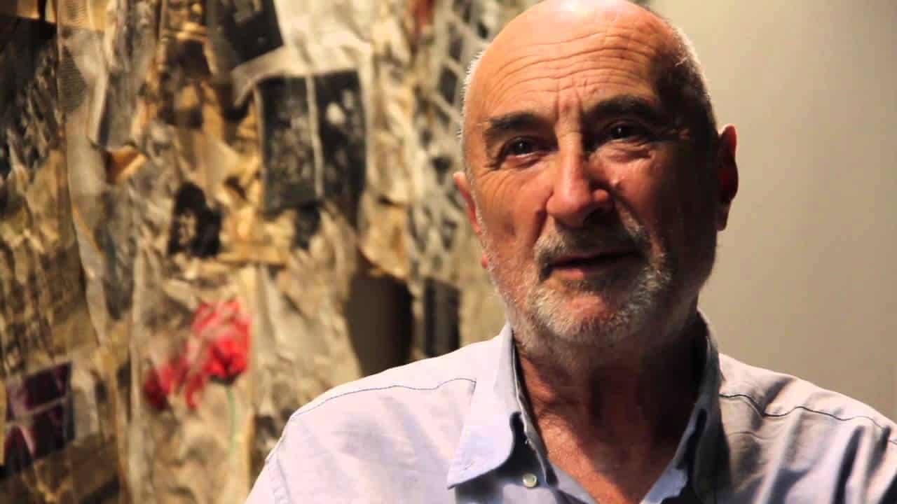
Agradezco a Camila por la oportunidad que dió de conocer un lugar único de una manera inusual (no como turistas)…ya me tocará volver. Juan Pablo Langlois Vicuña
I studied architecture at the Universidad Católica of Valparaíso from 1957 to 1962. I worked as an architect for about 10 years, but I was really more into visual art, so my interests drifted towards art making. I have been working in what I really felt like doing for 40 years now, without making too many concessions, living simply but without giving up on what I want to do, without worrying if I am in contact with “art” or not. That is why my artistic career has been independent of the social milieu of Chilean art. Solitary works have marked my trajectory, as well as the use of disposable materials that are easy and economic to get and work with, and works that are immersed as acts of my everyday life. I give more importance to the ideas than the product itself, and sometimes the products are no more than ideas. That is the way I have wandered through the arts, with varying intensity during these 40 years. With persistence and faith (and moments of loss of faith), I have positioned myself in the Chilean art scene.
Traveling to the southern city of Punta Arenas is a four-hour plane ride from Santiago and it leaves you with the sensation of having traveled to the southernmost part of world, yet in order to actually get to the last southernmost city in Chile, Puerto Williams, an additional journey descending 2° south is still necessary. Caleta María is approximately at 54º 30’ south.
We began our trip to Tierra del Fuego from Punta Arenas on the morning of Monday the 14th of February 2011. We were a group of 17 people in a four-truck convoy, traveling with our bags, gear and the food for one week strapped to the back of the pickups. We were headed to the vast territories of Karukinka, which extend alongside the northern front of Admiralty Sound, and reach Argentina in the east. The day we left the locality of Vicuña towards Lago Escondido, both camps inside Karukinka Natural Park, a fifth truck joined us with three people from the Punta Arenas Regional Council of Culture. Between Chileans and foreigners, we formed a group of 20.
But on that first day, after a 6-hour car ride, we arrived to Vicuña at dusk. This place would be our base-camp for 3 nights; many talks and presentations from members of the group took place here. These presentations were held normally in the morning after breakfast but also took place in the evening in the evening, either before or after dinner. Electricity was made possible thanks to a motor generator, charged with airplane fuel, which was turned on between the hours of 6:30 am and 11 pm. During the remaining time, flashlights and candles had to be used.
Adventurous treks and hikes became a crucial part of the program. Though we took many hikes, they all turned out to be different from one another due to the new things we learned from nature, the beauty of the landscape, and the difficulties and surprises of the routes and paths.
On Tuesday the 15th of February we climbed 200 meters to the peak of Cerro Pietro. From this rocky mountaintop, we could see an important part of the Río Grande valley. The wooded hills covered with lengas (nothofagus pumilio) looked like clouds of green vegetation in immense dimensions. The trail to the top was marked by wooden arrows, painted in a style reminiscent of the Selk’nam, hung on nearby trees. They were indispensable guides that kept us from losing our way, for the density of the woods left us disoriented, weakening the sense of where we stood.
Personally, the physical effort during this hike made me think many times about abandoning the quest. I was always the last one of the group, and if I didn’t give up, it was thanks to the moral support provided to me by Daniela Droguett. She waited and accompanied me, walking at my pace. Finally, I got to the top and… it was worth it.
The way down was via a short cut. It was a much more dangerous path during the first parts because of the steepness and slipperiness of the trail, like the treads of sheep. While walking down this part a strong and windy rainfall of hail caught us.
On Wednesday, February 16th, we started our excursion to Caleta María early in the morning. The distance varied according to the rhythm and pace of each one. The fastest ones walked for 6 hours, while I did it in 8 hours, resting for 10 minutes every hour. The journey started with a drive to the shore of the Lago Fagnano, where the trucks were left. After a frugal lunch, we crossed the lake on a military boat and started the hike crossing a very dense lenga forest.
What caught my attention was that in the middle of this forest other species such as the Canelo (the sacred tree of Mapuche culture) were growing. If these species were conserved, they would renew the trees of that part of the old forest.
During this journey, a great variety of plants presented themselves to us, such as a variety of wild berry that grew low in the ground. We also recognized a lot of mushrooms, but a lot of knowledge was needed to recognize the edible ones, differentiating them from the poisonous or hallucinogen.
Another curiosity for me were the balls of peat, covered with mushrooms, that had the shape of fettuccini. Like thick sponges full of water, your foot sunk around 50cm each time you inevitably stepped on them.
This journey required special equipment for the rain and wind. It required the intake of energetic food like chocolate, cookies, but especially water, which we could luckily take from the rivers we crossed, and that gave us also de pleasure of taking refreshing rests from the walk. I say this because during the 8-hour journey of the first day, and the 6-hour walk back the next day, we had spectacular sunny and warm days. It only rained the night we stayed at Caleta María. That night we made a bonfire and a barbecue, where we heated our food and also dried our clothes and shoes wet from the rivers and swamps.
The way back was organized in 3 groups with different schedules. Because I was the slowest of the group, I left with the first group at 9am in the morning. Everybody arrived at our destination at the same time.
On the way back I had the chance to see a very tiny carnivorous plant that feeds itself with insects. Its colors were of a strange dark pink, redder around the edges, like the interior of a human mouth. I was able to see again the canelo trees growing from the lengas. I thought about how they would soon be cut away due to the construction of a new road leading to Caleta María. This road will connect the territory of Tierra del Fuego with Admiralty Sound so that transportation will be easier for connectivity and tourism since nowadays that route can only be made by sea. Nevertheless, I asked myself whether the wide roads like the one being built by the military, which was at least 20 meters wide, are truly necessary, or if a solid and stable trail that wouldn’t interfere with the landscape and nature would be enough. This last thought is, in my opinion, worth revisiting collectively.
We returned to Vicuña on Thursday afternoon, to abandon the place the next morning and travel to Lago Escondido.
On Friday, February 18th at 10 in the morning, the convoy of 5 trucks started the journey to Lago Escondido, another of Karukinka’s camps, where we arrived at 3 in the afternoon of that same day. We walked around the place and enjoyed the amazing landscape it offered us. Some presentations were held that afternoon, We also organized the next day’s walk to Lago Escondido.
I didn’t participate in that hike because the place where we were staying was the closest I had ever been to paradise: the landscape, how far one can see, the sound of silence interrupted by the birds, the sound of the winding Río Grande, like a Renaissance painting. I wanted to enjoy that stillness, enjoy doing nothing.
When everybody left to Lago Escondido I started my contemplative and restful day. Camila lent me a book written by Lukas Bridges, about the days when he lived among the Yámanas. I read some chapters and imagined the rough yet beautiful life of the region during the 19th century and the beginnings of the 20th, the life he led traveling with his wife, who accompanied him through all these territories.
Then I sat down at a vista point and observed the plains that extend through the valley, the winding Río Grande, which with all of its meanders, looked like it was traveled from one side of the plain to the other. The pastures of the valley were flanked by hills covered with lengas and guanacos, resting or running followed by their babies. I also saw a lot of birds on the river shore, and a condor fly over the hills. The place I am describing had been -up to 1950- a wool and sheep farm, and the wooden structure of it was still in very good condition. The barns had taken on a grayish tone: everything was tinted with the silver-gray of the dead trees.
During the afternoon, 4 hours before the hikers arrived, a fire was prepared to roast a Magellanic lamb. In the middle of the pit, the fire was constantly lit and permanently fed with logs to keep it burning. At 9 in the evening, the lamb was ready to eat, and we started dinner with big bottles of wine. It was the celebration of the end of our days at Karukinka, and the beginning of our journey back from Tierra del Fuego.