
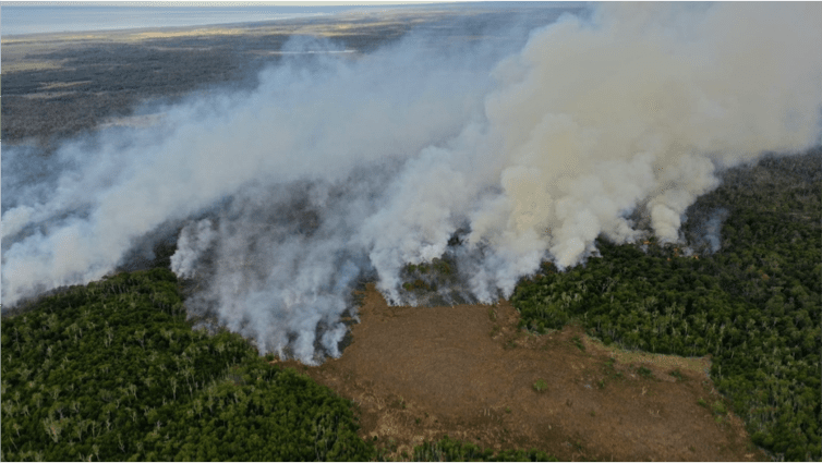
A forest fire that broke out in Tierra del Fuego on the 25th of January is directly threatening Karukinka Natural Park, administered by WCS Chile. This situation puts at risk valuable ecosystems that have for thousands of years been accumulating carbon, which could now be released into the atmosphere. This scenario would have repercussions not only for Chile–which has committed internationally to decreasing its emissions to reach a maximum of 95 million tons of greenhouse emissions by 2030–but also globally, gravely affecting climate change.
Despite a significant rollout of local forces and the goodwill of regional authorities, the isolated location of the region, complex ecological systems of the island, and lack of precipitation due to a severe and prolonged drought have rapidly driven the fire out of control. It has destroyed over 1,250 hectares (February 3rd) of native forest and peatlands according to CONAF (National Forest Corporation of Chile).
Karukinka Natural Park, part of ancestral Selk’nam territory, is home to approximately 130,000 hectares of primary native forest (the most austral and best-conserved at this latitude on the planet) and over 80,000 hectares of peatlands (80% of the peatlands on the Province). These ecosystems are home to Patagonian animals and birds like the guanaco, the Andean fox, the Magellanic woodpecker and the cachaña, the most austral parakeet in the world, all of whose livelihoods are today threatened by the advancing flames.
Alongside the overwhelming ecological richness of this remote and southmost park, which is four times the size of Santiago and roughly the size of Yosemite or the state of Rhode Island, WCS data shows that its forests and peatlands store over 418 million tons of CO2. This means that they have the potential to release the equivalent of 3 years’ worth of greenhouse gases into the atmosphere, according to the data obtained from the GEI (Chilean Greenhouse Gas Emissions Report 1990-2018).
More on Peatlands
Peatlands are a type of wetland of great value that contains and accumulates organic material in a state of semi-decomposition (peat), while also regulating the hydrological cycle that sustain forests. In this way, they conserve enormous reservoirs of freshwater that functions like a natural filter, reducing the transport of sediments to underground water sources. Peatlands are most efficient terrestrial carbon sink.
According to studies by Dr. Jorge Hoyos-Santillán and Dr. Armando Sepúlveda-Jauregui, researchers at the Environment Biogeochemistry Laboratory at the Universidad de Magallanes and the CR2, due to the lowering of the water table during summer months the level of water of the peatlands is below the surface. This leaves 1 to 2 meters of combustible organic matter at the surface level. When the fire reaches these wetlands, the destruction of even just one meter of peat will liberate up to 280 tons of carbon per affected hectare. This is equivalent to double the reservoir of carbon sequestered by a hectare of native Lenga forest. Nevertheless, if the fire penetrates deeper, the emissions will increase considerably, potentially reaching up to 623 tons per hectare.
Alongside the community of conservation ecologists of Chile, Turba Tol calls for the materialization of all the possible human effort, technical and financial, to combat fires and to focalize it in Tierra del Fuego with the outlook of extinguishing this threat. Once the emergency has passed, Turba Tol–in collaboration with numerous national and international partners including the WCS-Chile–will work towards the restoration of the damaged ecosystems and to establish an effective program of fire prevention so that we will never again have to face a disaster of this magnitude again on the island.
To support the emergency in any way please contact: info@turbatol.org
Un incendio forestal que se desató en Tierra del Fuego el pasado 25 de enero amenaza directamente al Parque Natural Karukinka, administrado por WCS Chile. Esta situación pone en riesgo valiosos ecosistemas que durante miles de años han estado acumulando carbono, que ahora podría ser liberado a la atmósfera. Este escenario tendría repercusiones no solo para Chile, que se ha comprometido internacionalmente a disminuir sus emisiones para alcanzar un máximo de 95 millones de toneladas de emisiones de efecto invernadero para 2030, sino también a nivel mundial, afectando gravemente el cambio climático.
A pesar de un importante despliegue de las fuerzas locales y la buena voluntad de las autoridades regionales, la ubicación aislada de la región, los complejos sistemas ecológicos de la isla y la falta de precipitaciones debido a una severa y prolongada sequía han hecho que el fuego se salga rápidamente de control. Ha destruido más de 1.250 hectáreas (3 de febrero) de bosque nativo y turberas según CONAF (Corporación Nacional Forestal de Chile).
El Parque Natural Karukinka, parte del territorio ancestral Selk’nam, alberga aproximadamente 130.000 hectáreas de bosque nativo primario (el más austral y mejor conservado a esta latitud del planeta) y más de 80.000 hectáreas de turberas (el 80% de las turberas del la provincia). Estos ecosistemas son el hogar de animales y aves patagónicas como el guanaco, el zorro andino, el pájaro carpintero de Magallanes y la cachaña, la cotorra más austral del mundo, todos cuyos medios de vida se ven hoy amenazados por el avance de las llamas.
Junto con la abrumadora riqueza ecológica de este parque remoto y más al sur, que es cuatro veces el tamaño de Santiago y aproximadamente el tamaño de Yosemite o el estado de Rhode Island, los datos de WCS muestran que sus bosques y turberas almacenan más de 418 millones de toneladas de CO2. Esto significa que tienen el potencial de liberar a la atmósfera el equivalente a 3 años de gases de efecto invernadero, según los datos obtenidos del GEI (Informe de Emisiones de Gases de Efecto Invernadero de Chile 1990-2018).
Más sobre las turberas
Las turberas son un tipo de humedal de gran valor que contiene y acumula materia orgánica en estado de semidescomposición (turba), a la vez que regula el ciclo hidrológico que sustenta los bosques. De esta forma, conservan enormes reservorios de agua dulce que funcionan como un filtro natural, reduciendo el transporte de sedimentos a las fuentes de agua subterránea. Las turberas son los sumideros terrestres de carbono más eficientes.
Según estudios del Dr. Jorge Hoyos-Santillán y el Dr. Armando Sepúlveda-Jauregui, investigadores del Laboratorio de Biogeoquímica Ambiental de la Universidad de Magallanes y del CR2, debido al descenso del nivel freático durante los meses de verano el nivel del agua de la turberas está debajo de la superficie. Esto deja de 1 a 2 metros de materia orgánica combustible a nivel superficial. Cuando el fuego alcance estos humedales, la destrucción de un metro de turba liberará hasta 280 toneladas de carbono por hectárea afectada. Esto equivale a duplicar el reservorio de carbono secuestrado por una hectárea de bosque nativo de Lenga. Sin embargo, si el fuego penetra más profundamente, las emisiones aumentarán considerablemente, llegando potencialmente a 623 toneladas por hectárea.
Junto a la comunidad de ecologistas conservacionistas de Chile, Turba Tol llama a materializar todo el esfuerzo humano, técnico y económico posible, para combatir los incendios y focalizarlo en Tierra del Fuego con miras a extinguir esta amenaza. Una vez superada la emergencia, Turba Tol, en colaboración con numerosos socios nacionales e internacionales, incluido WCS-Chile, trabajará en la restauración de los ecosistemas dañados y establecerá un programa eficaz de prevención de incendios para que nunca más tengamos que enfrentarnos. De nuevo un desastre de esta magnitud en la isla.
Para apoyar la emergencia de alguna manera por favor contactar: info@turbatol.org